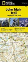
National Geographic Trails Illustrated John Muir Trail California Topographic Map Guide 1001. Great for Camping, Fishing, Hunting, Hiking, Backpacking, Family Outings, Outdoor Adventure.
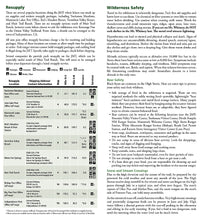
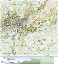
National Geographic’s Map Guide of the John Muir Trail is an indispensable tool for navigating one of the most famous trails in the United States. Expertly researched and created in partnership with local land management agencies, this product provides detailed topographic maps, interesting history, a waypoint table, information about resupply and bear safety, and key points of interest you will encounter along the trail. Formatted to meet your needs while navigating this breathtaking and remote trail, the maps within the guide are one-inch-equals-one-mile (1:63,360) making it easy to calculate distances.
Each map page has a trail profile that shows the elevation changes you will encounter. Also, the John Muir Trail is highlighted and centered on each page so you can easily track your progress. The maps start at the northern terminus in Yosemite Valley and progress along the ridge of the Sierra Nevada, past Devils Postpile, and end at the highest point in the lower 48 on the top of Mount Whitney. Along the way you will pass through; Yosemite National Park, Ansel Adams Wilderness, Devils Postpile National Monument, John Muir Wilderness, Kings Canyon National Park, and finally, Sequoia National Park and Mount Whitney.
More than just a map, National Geographic Trails Illustrated topographic maps are designed to take you into the wilderness and back. Printed on tear-resistant, waterproof material, this map can go anywhere you do. Each map is based on exact reproductions of USGS topographic map information, updated, customized, and enhanced to meet the unique features of each area. The maps include valuable wilderness tips and Leave No Trace guidelines, along with updated trails, trailheads, points of interest, campgrounds, and much more. With a new color palette and stunning shaded relief, backcountry navigation has never been easier.
Trails Illustrated maps are expertly researched and frequently updated. The maps are printed in the United States on durable synthetic paper, making them waterproof, tear-resistant, and trail tough — capable of going anywhere you do. The map is two-sided, and can be folded to a packable size of 4.25" x 9.25".
All proceeds from the purchase of National Geographic maps help support the Society’s vital exploration, conservation, scientific research, and education programs.
Key Features:
- Waterproof and tear-resistant
- Clearly marked trails for hiking, biking, horseback riding, and more
- Detailed topography and clearly defined, color-coded boundaries of state parks, national recreation areas, wilderness areas, marine sanctuaries and wildlife refuges
- Hundreds of points-of-interest, including scenic viewpoints, campgrounds, boat launches and canoe carry downs, swimming areas, fishing access points, and more
- UTM and Latitude/Longitude grid, as well as selected waypoints and a scale bar for easy and accurate navigation.
- Detailed road network
- Useful travel information on parks and key trails
- Important safety information and tips
- Information about local organizations and land management agencies
Requirements: None.
TIP: This item is also available in money-saving 2-packs and 3-packs! Go to our store, then browse our Discounted Multi-Packs Store category, or use the Store search tool to find items quickly.
You will receive: 1 National Geographic Trails Illustrated Map.
Retail packaging, shipped in a poly envelope. Shipping weight 4 oz.
If you have any questions or concerns, please contact us before or after the sale - we want you to be a happy customer!
Thanks for looking!


