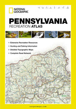
National GeographicPennsylvania StateRecreation Atlas Map Road Topo Maps ST01020731. Greatfor Camping, Fishing, Hunting,Hiking, Backpacking, Family Outings, Vacations, Outdoor Adventure, Road Trips.
This listing is for thePennsylvania Recreation Atlas Product #1020731.For other states just do a quick search in our store.
Product Features:
- Each labeled feature is up to date and verified by satellite image
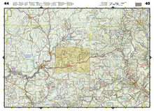
- Comprehensive, easy-to-read road network
- Boundaries for parks and federal lands
- Clearly labeled lakes, rivers, and streams
- Durable laminated cover
- Robust travel and recreation information
- Cross-referenced chart of fishing areas with species information
- Game management units
- Campgrounds and attraction charts
- State Parks maps and facilities
- Hiking, golfing, and paddling destinations
- Climate information
TIP 1: For lower prices on our atlases, map kits, paper, and folded wall maps, check out our promotions (click the link above the picture). Here is the info: Purchase 2 and get 5% off, 3 or more will get you 10% off! This promo includes ALL of our atlases, map kits, and folded wall maps. For example, purchase 1 National Geographic Benchmark atlas, 1 Delorme atlas, and 1 folded wall map (total of 3) and get 10% off!! Just put everything in your shopping cart and you will see the savings!
TIP 2: We have a huge selection and great prices on our map products! Click here to go to our store, click on the store category called Maps & Books, then browse our sub-categories, or use the Store search tool to find items quickly.
Requirements: None.
You will receive: 1National GeographicRecreation Atlas.
Retailpackaging, shipped in a poly envelope. Shipping weight 2 lbs.
If you have any questions or concerns, please contact us before or after the sale - we want you to be a happy customer!
Thanks for looking!


