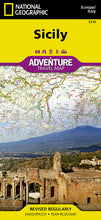
BRAND NEW National Geographic Island of Sicily, Italy Europe Adventure Travel Map.
• Waterproof • Tear-Resistant • Travel & Road Map
Explore the vibrant history and rural beauty of the largest island in the Mediterranean Sea with National Geographic's Sicily Adventure Map. This expertly crafted map provides global travelers with the perfect combination of detail and perspective, highlighting hundreds of points of interest and many diverse and unique destinations within the country including national parks, archeological sites, prehistoric monuments, museums, palaces, castles, churches, and more. Cities and towns are clearly indicated and easy to find in the user-friendly index. A road network complete with distances and designations for motorways, expressways, scenic routes and more will help you find the route that's right for you.
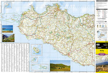
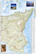
Sicily's western half is shown on the front side of the print map including the cities of Trapani, Palermo, Caltanissetta, Licata, Agrigento, Sciacca, Marsala, and Mazara del Vallo. Inset maps of Isola di Ustica, Isola di Pantelleria, Isola di Linosa, and Isole Pelagie provide greater detail of the islands. The reverse side of the map covers the eastern portion of the region and shows the cities of Gela, Syracuse, Catania, Messina, and Milazzo and an inset map of Isole Lipari.
Sicily is Italy's most agricultural region with rich vineyards and orchards thriving in the fertile volcanic soils of Mount Etna, the tallest active volcano in Europe. Greek colonies established in the eighth century B.C., left ruined temples and theaters that are now some of the island's most popular tourist attractions.
Every Adventure Map is printed on durable synthetic paper, making them waterproof, tear-resistant and tough — capable of withstanding the rigors of international travel.
Features:
- Waterproof and tear-resistant
- Easy to find cities and towns
- Roads are clearly marked with distance in kilometers
- Hundreds of recreational, historical, and cultural destinations are clearly marked
- Updated regularly to ensure accuracy
- Scale: 1:225,000
- Folded Size: 4.25" x 9.25"
- Flat Size: 25.5" x 37.75"
- Weight: Approx. 3.4 oz
TIP: For lower prices on our maps, check out our promotions (click the link above the picture). Here is the info: Purchase 2 - 3 maps and get 10% off, 4 or more will get you 15% off! This promo includes ALL of our maps. For example, purchase 2 Trails Illustrated maps, 1 Destination map, and 1 Adventure map (total of 4) and get 15% off!! Just put everything in your shopping cart and you will see the savings!
Requirements: None.
You will receive: 1 National Geographic Adventure Travel Map.
OEM packaging, shipped in a poly envelope. Shipping weight 4 oz.
If you have any questions or concerns, please contact us before or after the sale - we want you to be a happy customer!
Thanks for looking!


